By Andrew Maximow, Chief Drone Officer
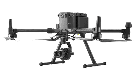
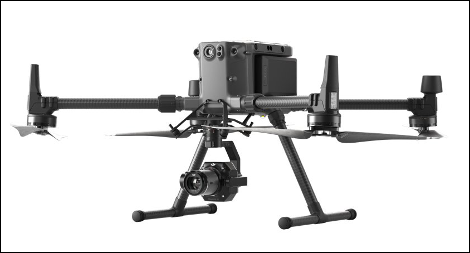
DJI introduced the M300 platform to the public safety and inspection markets a few months ago. Shortly after the announcement, I wrote an article lamenting the lack of mapping capability and the absence of appropriate RGB camera sensors. I was disappointed with what seemed like complete disregard to the 3D mapping market. A reader commented, predicting a suitable mapping camera in 6 months. My regular sources at DJI were silent. I was skeptical. Others anticipated third party support via DJI’s SDK and their Skyport payload interface.
The summer of 2020 went by rather uneventfully with increased anti-DJI sentiments in the headlines and some obscure third party offerings like the oblique cameras from Chengdu Rainpoo Technology or Share PSDK Tec, both from China. I’m not exactly rushing out to buy one of these yet. The irony is that the specs of the M300 are impressive including 55 min flight times, advanced dual control and weather resistance – nice feature enhancements to a high mapping platform.
Meanwhile, we were dealing with a few incidents with our fixed-wing platforms that required significant repairs and frustrating downtime. It got me thinking that this wouldn’t happen with a multi-rotor vehicle and that 55 minute flight time! Well ok, maybe not 55 minutes, but I’ve been dreaming about a multi-rotor that could exceed the upper limits of 20 – 30 minutes from any other offerings. Imagine the area you could cover on a single battery charge. Oh, and the $11k price for a loaded M300 vehicle, not bad. But $700 per battery, and you need 2…yikes! That’s almost $7,000 for batteries if you have continuous operations. Holy cow! Ahh, if only the M300 could map.
But suddenly, my dreams were realized in several ways that exceeded my expectations. First, DJI announced the L1 LiDAR payload and support for the M300. At Firmatek, we were anticipating some sort of offering for the M210 and a LIVOX payload but a low-cost plug-n-play solution for the M300 was a welcome surprise. Can’t wait to get our hands on the L1 and check the point cloud data for several of our use cases.
Almost immediately thereafter, DJI announced the P1 photogrammetry camera with a 45 MP, mechanical shutter CMOS sensor. That was unexpected, or was it? It caught us by surprise! DJI did a great job of keeping that one a secret. There is very little information about the P1 performance from the 3D mapping user community and even less info from DJI, so it’s a bit of head scratcher. At $9k it’s a bit pricey. I’m certainly not going to run and buy one any time soon. One can pre-order the P1 now with expected ship date in the first quarter of 2021. I need to do some math and think about whether an M300/P1 ($29k fully loaded) is worth 3x compared to the P4-RTK ($9k).
As I ponder the comparison, I notice that DJI’s marketing material claims the M300/P1 combo can map roughly 740 acres on 1 set of batteries. That almost makes the $700 batteries worth it. Then it hit me, maybe I’m comparing it to the wrong drone. Suddenly, the specs on the M300/P1 look more like that of a fixed-wing…45-55 min flight time, 740 acres without the messy takeoff/landings. Maybe what we have here is a fixed-wing killer? In reality, I don’t see fixed-wing drones disappearing any time soon but this is the first time that a multi-rotor’s performance capabilities approach those of a fixed-wing. Considering some of the benefits of the M300 (weather resistance, hot-swap batteries, and total cost of ownership) they start to outweigh the value prop of the fixed-wing.
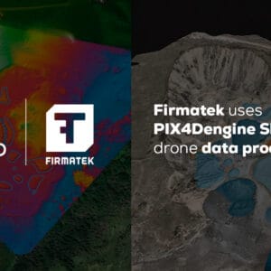
To sweeten the pot, GeoCue Group announced the True View 250 payload for the M300. Game on! This is something I’ve been bugging the engineering team about at GeoCue for at least a year. This is truly exciting considering the price for performance of the True View 410, which Firmatek owns and uses. The True View 250 is essentially the True View 410 without the LiDAR sensor that is optimized for photogrammetry mapping mission types. It’s no surprise we are big fans of the True View 3DIS systems and with the proven capability and accuracy of the GeoCue photogrammetry camera.
With the added capability of the LiDAR and photogrammetry, this makes the M300 the most universal multi-rotor platform in history. With the promise of plug-n-play swappable payloads like the H20T for inspection use-cases, and now the L1 for LiDAR scanning, and P1 and TV250 options for photogrammetry mapping, this makes the DJI M300 and truly versatile next generation UAV platform.

About Andrew
Andrew Maximow joined Firmatek as Chief Drone Officer. Andrew spent his professional career in fast-growth technology domains, progressively moving from engineering to leadership roles. Prior to joining Firmatek, Andrew served as a managing partner with Texas-based drone services company, Drone Dynamics, and led the Enterprise Services team at 3D Robotics. Andrew possesses BS & MS degrees in Industrial & Systems Engineering.
Recent Articles:
Implications of the Recent FAA Remote ID Proposal
Is the Construction Industry Ready to Digitize?