By Andrew Maximow, Chief Drone Officer
A variety of industries utilize drone and LiDAR solutions to streamline their operations. Mining and aggregates are accurately measuring materials, landfills are calculating remaining airspace, and public service departments are using tech to assist in search and rescue missions. The electrical utilities industry has also discovered the many benefits of using advanced technology to improve site management. As we continue to expand our capabilities, we’ve developed our service offering to provide solutions for the growing needs in utility mapping. In this article, we’ll discuss four use cases for the electrical utility industry that can be divided into the following categories, based on the data-collection technology being deployed.
The Four Categories
- LiDAR – Stationary, mobile, or UAV-based laser sensors are used to create point clouds. Deliverables include measurements (linear, area, volumetric) and 3D models.
- CVI (RGB) – UAV-based high resolution cameras are used for capturing still photos, videos used to spot defects, anomalies, and change detection in electrical components.
- Emergency Response – UAVs are utilized to assess storm damage post disaster.
- Thermal – Emerging technology is typically used to spot electrical faults by locating “hot spots” or gathering radiometric data (temperature).
Use Cases for LiDAR
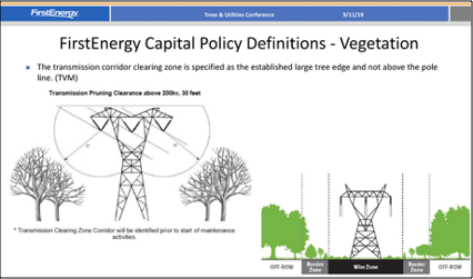
Right of Way (ROW) Vegetation Encroachment
Helicopters have traditionally been used to capture LiDAR data to identify types of vegetation that are currently encroaching or will potentially interfere in the short or long term.
Helicopters are costly, risky, and a scarce resource. With the increased demand for regulatory compliance, there will be a greater reliance on mobile and UAV-based LiDAR to quickly, safely, and cost effectively measure vegetation encroachment, especially in urban and populated areas.
Deliverables:
- Vegetation encroachment reports. Results sent out to bid for vegetation mitigation (cutting trees, clearing brush)
- Regulatory compliance reporting
- Annual budget reports
- Vegetation prediction models
- Liability assessment predictions
ROW Modeling
Mobile and UAV LiDAR is used to model and measure ROW corridors that may be shared or adjacent to road ways, railroad tracks, pipelines, waterways, or electrical lines from other utilities. LiDAR is used to measure distances and verify boundaries of existing infrastructure or future expansion plans.
Deliverables:
- Dimensioned CAD drawings indicating key features; tower/structure, roadway, railroad, etc. Results indicate where ROW overlaps or conflicts used to resolve ROW disputes.
- As-built CAD drawings used for documentation and project completion on new infrastructure expansion & construction.
Measuring Transmission Line (Catenary) Sag
LiDAR is used to measure line catenary sag of transmission lines, which impacts the load that can be carried by the line.
Deliverables:
- Line sag measurements are used by engineering load studies
- Useful for canyon or water crossings involving long spans between poles/structures
Communication Line Attachment Inventory
Distribution pole space is leased to 3rd party communications services providers like internet, cable TV, and telephone companies, and is billed by “line attachment” per pole. Periodic surveys are required to verify attachments and determine capacity for new services. LiDAR captures the distance between attachment points and the ground. Projects specs typically include tens of thousands of poles.
Deliverables:
- Line Attachment reports indicating type of attachment (fiber, coax, tp), name of provider, etc. Used to resolve short-fall in revenue for electrical utilities
- Determines capacity for new fiber “make ready” projects
- Plan of record
Power Pole & Tower/Structure As-builts
Electrical Utilities require accurate as-built drawings of major power poles and tower/structure. LiDAR mapping provides accurate (x, y, z) GPS location.
Deliverables:
- Dimensioned CAD drawings
- 3D models with object/feature code classification
- Input for geospatial database (Typically ESRI)
- New construction/installation verification
- Capacity planning assessments
- Plan of record
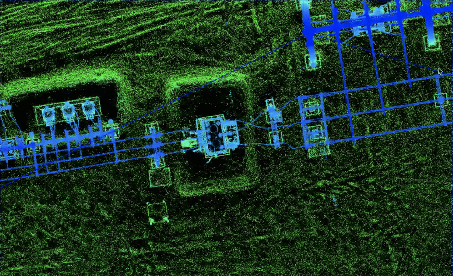
Substation modeling & as-builts
Electrical Utilities require accurate as-builts of all substations, switching stations, and other infrastructure, including component inventory (circuits, transformers, etc.) LiDAR mapping provides accurate (x, y, z) GPS location.
Deliverables:
- Dimensioned CAD drawings
- 3D models with object/feature code classification
- Input for Geospatial data base (Typically ESRI)
- New construction/installation verification
- Capacity planning assessments
- Plan of record
Use Cases for RGB Cameras – Comprehensive Visual Inspection (CVI)
Comprehensive Visual Inspection (CVI)
Electrical Utilities require the ongoing, proactive, and comprehensive inspection of the following transmission and distribution line components.
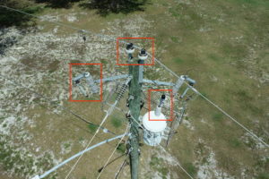
Deliverables:
- Transmission tower (H-frame, lattice, mono-pole) components (attachment points, insulators, transformers, risers, dampening, grounding)
- Distribution pole components (attachment points, insulators, transformers, risers)
- Pole condition (pole rot, crossbeam integrity, moss, birds nests, corrosion)
- Failures (missing grounding, flash overs, attach point wear & tear)
New Construction/Installation Verification
RBG cameras are used to verify new installation, construction, and post storm damage remediation work performed by sub-contractors.
Deliverables:
- Still photos/video
- As-built dimensioned drawings
Emergency Response
LiDAR and UAVs offer a high value-add service involving stand-by capability to perform post storm and natural disaster assessment and remediation. Utilizing this technology contributes to rapid service restoration. There is strong potential for integrating accurate infrastructure database with change detection to rapidly determine which components need to be replaced.

Deliverables:
- Situational awareness and rapid damage assessment of inaccessible areas
- Damage assessment reports (pole down, line down, trees down, flooding, etc)
- Remediation verification
- Service damage assessment used to create a bill of materials (BOM), of equipment and components needed to repair and restore service
Thermal
Thermal/IR is primarily and extensively used to evaluate the integrity of vast PV solar panel farms. Thermal hot-spots are a strong indication of an electrical fault in a panel or connection. Similarly, thermal/IR is being used to determine electrical faults in connection points, faulty components, and other potential problems. There is strong potential to automate this process.
Thermal can be used either subjectively to identify hot spots that require further investigation by trained personnel, or objectively measuring radiometric (temperature) data. Future developments include automation, machine learning, and AI.
While some utilities continue to experiment with home-grown UAV departments, the general trend is to experiment, test, figure out the technology, and ultimately outsource to competent, reliable, cost effective professional services subcontractors like Firmatek. Building UAV, drone-based capabilities is not a core competency for most electrical utilities. Manual asset monitoring is time consuming, costly, and often dangerous. With Firmatek’s inspection solutions, we help minimize risks and maintain strength and resiliency to keep your systems as strong as the communities you serve.
For more information on our utility solutions, download our flyer here.
About Andrew 
Andrew Maximow joined Firmatek as Chief Drone Officer. Andrew spent his professional career in fast-growth technology domains, progressively moving from engineering to leadership roles. Prior to joining Firmatek, Andrew served as a managing partner with Texas-based drone services company, Drone Dynamics, and led the Enterprise Services team at 3D Robotics. Andrew possesses BS & MS degrees in Industrial & Systems Engineering.
Recent Articles:
Implications of the Recent FAA Remote ID Proposal
Is the Construction Industry Ready to Digitize?